
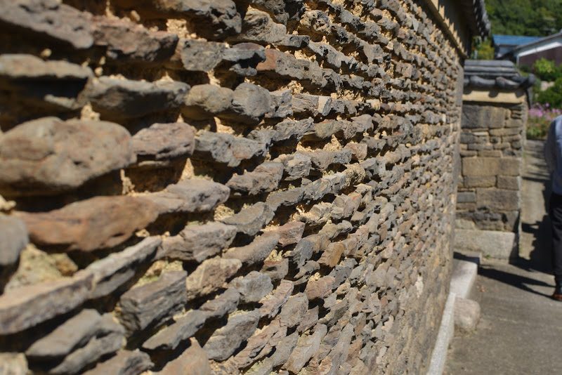
![【兵庫】日本最古の民家「箱木千年家(はこぎせんねんや)」 – [Hyogo] Japan’s oldest private residence, ‘Hakogi Sennnenya’](https://yousakana.jp/wp-content/uploads/wordpress-popular-posts/54076-featured-120x120.jpg)

![【香川】春日川の川市 – [Kagawa] River market of Kasuga river](https://yousakana.jp/wp-content/uploads/wordpress-popular-posts/49605-featured-120x120.jpeg)
![【毎年6/15】初夏の風物詩、満濃池のゆる抜き - [Kagawa 6/15] "Mannou pond", Seasonal event of releasing water from a reservoir](https://yousakana.jp/wp-content/uploads/wordpress-popular-posts/11598-featured-120x120.jpg)
![【高知】魚を守る道、アイスハーバー型らせん魚道 – [Kochi] Ice Harbor type spiral fishway](https://yousakana.jp/wp-content/uploads/wordpress-popular-posts/50244-featured-120x120.jpeg)


![【直島】泊まれる美術館、ベネッセハウス – [Naoshima island] Stay in the Art Museum “Benesse House”](https://yousakana.jp/wp-content/uploads/2020/12/Benesse-Art-Site-Naoshima-1-800x533.jpg)
![【香川】丹下健三設計「船の体育館」取り壊しが決まっている香川の文化遺産をホテルに – [Kagawa] Kenzo Tange’s ‘Boat Gymnasium.’ A cultural heritage site in Kagawa that is scheduled for demolition will be converted into a hotel.](https://yousakana.jp/wp-content/uploads/2025/07/Former-Kagawa-Prefectural-Gymnasium-Restoration-Committee-16_c-800x534.jpg)
![【香川】王墓山古墳(おうはかやまこふん) – [Kagawa] Ohakayama burial mound](https://yousakana.jp/wp-content/uploads/2022/04/Ohakayama-burial-mound-02-800x533.jpg)
![【香川 8/13-15】万灯みたままつり 讃岐宮 護国神社 – [Kagawa 13-15 Aug.] Manto-Mitama Festival, Sanukigu Gokoku Shrine](https://yousakana.jp/wp-content/uploads/2023/08/panorama_gokoku-shrine_mitama-fes_zentsuji-800x533.jpeg)

![【閉店】あんもち雑煮。甘味茶寮 ほとり – [Closed] Japanese tea and sweets “Hotori”](https://yousakana.jp/wp-content/uploads/2019/12/hotori_japanese-tea-and-sweets-800x534.jpg)
![【香川】ちょうさが集まる瀬戸内の秋祭り「白羽神社 秋祭り」 – [Kagawa] Shrine Autumn Festival with CHOUSA at Setouchi](https://yousakana.jp/wp-content/uploads/2015/09/DSC_01051-800x536.jpg)
![【香川】浦島伝説が残る荘内半島の花畑『フラワーパーク浦島』 – [Kagawa] Flower park Urashima](https://yousakana.jp/wp-content/uploads/2025/05/urashima-flower-park-800x534.jpg)
![【香川 1/11】高松市消防出初式 – [Kagawa 11 Jun] The Firefighter New Year’s Ceremony](https://yousakana.jp/wp-content/uploads/2026/01/The-Firefighter-New-Years-Ceremony-800x533.jpg)
![【香川】屋島山上交流拠点施設『やしまーる』 – [Kagawa] The Yashima Exchange Center “Yashimāru”](https://yousakana.jp/wp-content/uploads/2022/07/yashimaru_kagawa_takamatsu-800x534.jpeg)
![【香川】讃岐らぁ麺 伊吹いりこセンター – [Kagawa] Sanuki ramen, Ibuki Iriko Center](https://yousakana.jp/wp-content/uploads/2022/12/Sanuki-ramen-Ibuki-Iriko-Center-800x534.jpeg)
![【島根】出雲神話の舞台『稲佐の浜』 – [Shimane] Inasa Beach, the setting of the Izumo myth](https://yousakana.jp/wp-content/uploads/2025/07/inasa-beach_shimane_izumo-1-800x534.jpg)
![【香川 国の登録有形文化財】築100年以上の古民家『松賀屋』 – [Kagawa National tangible cultural property] “Matsugaya”, Traditional Japanese House](https://yousakana.jp/wp-content/uploads/2018/07/matsugaya_nio_mitoyo-800x534.jpeg)
![【徳島 8/12-15】阿波おどり ― 400年続く徳島の夏の熱狂 – [Tokushima 12-15 Oct.] Awa Dance Festival, Tokushima’s 400-year-old summer extravaganza](https://yousakana.jp/wp-content/uploads/2025/08/DSC_0358-800x536.jpg)
![【香川】地球で冷やした冷風が吹き抜ける!高鉢山の風穴 – [Kagawa] Earth-cooled winds blow through! Blowing cave in Mt. Takahachi](https://yousakana.jp/wp-content/uploads/2024/07/Blowing-cave_fuketsu_mt-takahachi-800x533.jpg)
![【高知】おやつの神さまが集まるイベント「おやつ神社」 – [Kochi] OYATSU JINJYA(Shrine)](https://yousakana.jp/wp-content/uploads/2017/10/oyatsu-shrine-800x534.jpg)
![【愛媛 1/12(月)】新居大島 とうどおくり – [Ehime 1/12(Mon.)] Toudo festival at Ni-Oshima island](https://yousakana.jp/wp-content/uploads/2020/01/toudo_nioshima-island.jpg)
![【香川】焼菓子工房 ボンボニエール – [Kagawa] Baked Confectionery Bonbonniere](https://yousakana.jp/wp-content/uploads/2021/05/bonbonniere_title-800x533.jpg)

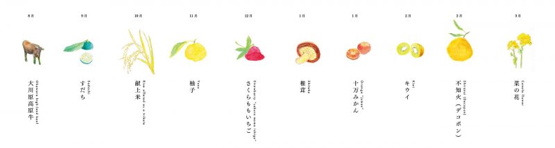
![【徳島】神山町江田、棚田に菜の花の黄色い絨毯 – [Tokushima] The beautiful field mustard at Kamiyama](https://yousakana.jp/wp-content/uploads/2016/03/nanohana-kamiyama-800x533.jpg)
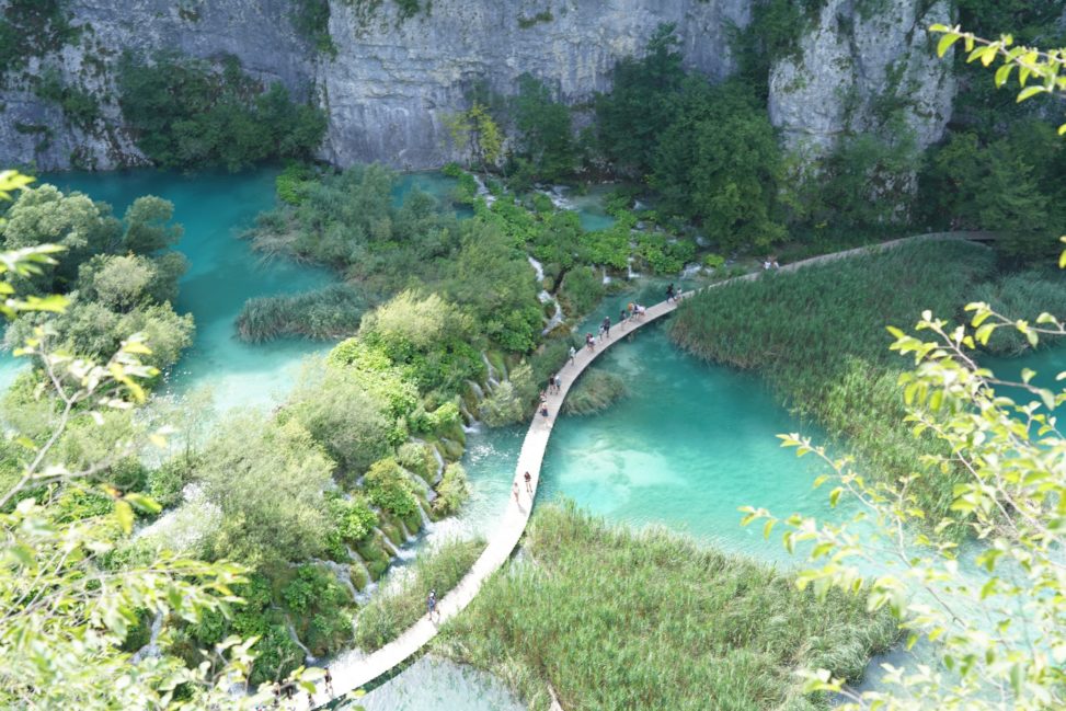
クロアチアの世界遺産 『プリトヴィツェ湖群国立公園(Plitvice Lakes National Park)』にやってきました。ボスニア・ヘルツェゴビナの国境付近にある大小16の湖と92の滝とブナの原生林が創り出すエメラルドグリーンの美しい景観。1267種の植物(75種は固有種)、259種の動物が生息しています。
白雲岩(ドロマイト)と石灰岩のカルストからなる地質が特徴的な地形を生み出し、数千年かけて藻や苔類によって蓄積されたトラバーチン(Travertine、石灰質化学沈殿岩、石灰華)の働きで美しい水質が保たれています。
1991年〜1995年 クロアチア紛争の戦火の中でこの自然を守りたいと考えたクロアチアの人々によってユネスコの危機遺産申請。1992年に国連保護軍が公園内に入り、1995年に紛争終結、1997年に危機遺産リストから除去され守られた自然公園です。
Plitvice Lakes National Park
Address : Lika-Senj County, Karlovac County, Croatia [Google Map]
チケット


立入禁止区域

立入禁止


Plitvice Lakes National Park
Address : Lika-Senj County, Karlovac County, Croatia [Google Map]General information – Nacionalni park "Plitvička jezera"
Plitvice Lakes is the oldest and largest national park in the Republic of Croatia. The park is situated in the mountainous region of Croatia, between the Mala Kapela mountain range in the west and northwest, and the Lička Plješivica mountain range to the southeast. Administratively, the park falls within two counties: Lika-Senj (90.7%) and Karlovac (9.3%).
With its exceptional natural beauty, this area has always attracted nature lovers, and already on 8 April 1949, it was proclaimed Croatia’s first national park. The process of tufa formation, which results in the building of the tufa, or travertine, barriers and resulted in the creation of the lakes, is the outstanding universal value, for which the Plitvice Lakes were internationally recognised on 26 October 1979 with their inscription onto the UNESCO World Heritage List. In 1997, the boundaries of the national park were expanded, and today it covers an area just under 300 km2.
The park is primarily covered in forest vegetation, with smaller areas under grasslands. The most attractive part of the park – the lakes – cover just under 1% of the total park area.
The lake system is comprised of 16 named and several smaller unnamed lakes, cascading one into the next. Due to the geological substrate and characteristic hydrogeological conditions, the lake system has been divided into the Upper and Lower lakes. The twelve lakes forming the Upper Lakes are: Prošćansko jezero, Ciginovac, Okrugljak, Batinovac, Veliko jezero, Malo jezero, Vir, Galovac, Milino jezero, Gradinsko jezero, Burgeti and Kozjak. These lakes were formed on impermeable dolomite rock, and are larger, with more indented and gentler shores than the Lower Lakes. The Lower Lakes, consisting of the lakes Milanovac, Gavanovac, Kaluđerovac and Novakovića Brod, were formed in permeable limestone substrate, cut into a deep canyon with steep cliffs. The lakes end in the impressive waterfalls Sastavci, with the Korana River springing under the base of the falls.
The Plitvice Lakes National Park offers visitors seven different routes to tour the lake system, and four hiking trails. The park is open to visitors year round. All visitors are required to follow the instructions listed on the information panels, to keep on the marked trails, and to leave no traces of their visit, such as litter, or marking or devastating nature in any form.
Plitvice Lakes National Park – Wikipedia
Plitvice Lakes National Park (Croatian: Nacionalni park Plitvička jezera, colloquially Plitvice, pronounced [plîtʋitse]) is one of the oldest and largest national parks in Croatia.[2] In 1979, Plitvice Lakes National Park was added to the UNESCO World Heritage register.
The national park was founded in 1949 and is in the mountainous karst area of central Croatia, at the border to Bosnia and Herzegovina. The important north–south road that passes through the national park area connects the Croatian inland with the Adriatic coastal region.
The protected area extends over 296.85 square kilometres (73,350 acres). About 90% of this area is part of Lika-Senj County, while the remaining 10% is part of Karlovac County.
Each year, more than 1 million visitors are recorded. Entrance is subject to variable charges, up to 250 kuna or around €34 per adult per day in summer 2018.
History
While other nature protection areas are located far away from any interference by man, the Plitvice Lakes have permanently been exposed to human influence in the course of history. The Plitvice Lakes do not represent an abandoned or lonely nature reserve. They are located along an important transport route and have always been a meeting place of occidental and oriental cultural influences.
地理学的・地質学的特色
プリトヴィツェ湖群は一般にディナル・アルプス山脈と呼ばれる山地に点在するカルスト地形の1つで、 Lička Plješevica山(Gornja Plješevica山頂の標高1640m)、Mala Kapela山(Seliški vrh山頂の標高1280m)、Medveđak山(標高884m)の山間に広がるプリトヴィツェ台地に位置し、湖群名もこの台地名によっている。16の湖は、山間から流れ出てくる水が標高636mから503mまで、およそ8kmにわたって南北方向に流れる中で形成されており、上流の湖群と下流の湖群がある。湖群はおよそ2km2に渡って広がり、一番大きな滝は下流のプリトヴィツェ川が流れ込んでできた大滝(78m)で、 湖群の最下流にある湖からコラナ川(Korana)に流れ出す。
一帯の地質は主にドロマイト(白雲岩)と石灰岩のカルストからなり、このことが際立って特徴的な景観が生まれる素因となっている。湖群は、コケ類、藻類、バクテリアなどの光合成が関与して生まれた石灰質堆積物(石灰華)の自然のダムからできている。植物片を混じえた堆積物は年々積み重なり、年1cmの割合で堆積物のダムが高くなっていく。
湖群は紺碧、紺青、灰色など、目を見張るような色合いをもつ。水の色はミネラルや有機物の量、あるいは日照の角度などによって絶え間なく変化する。
植物相と動物相
プリトヴィツェ国立公園は主にナラやトウヒ、モミなどからなる鬱蒼とした森林に覆われアルプスと地中海の植生が渾然となっている。特に植物群落の多様性が特筆に価するがそれは微気候のラインナップ、多様な土壌、標高差などによって生み出されている。一帯は同時に動物種や鳥類に関しても際立った多様性を示している。ヨーロッパ種のヒグマやオオカミ、ワシミミズク、ワイルドキャット、オオライチョウといった稀少な動物種が見られるほか、より一般的な動物種も多く棲息する。鳥類は少なくとも126種が記録され、そのうち70種以上がこの湖群を繁殖地としている。
More from my site
![【香川】瀬戸内海とつながる給水スポット!高松市役所に給水スポットが完成 – [Kagawa] A water supply spot has been completed at Takamatsu City Hall!](https://yousakana.jp/wp-content/uploads/2023/06/IMG_7020-150x150.jpg) 【香川】瀬戸内海とつながる給水スポット!高松市役所に給水スポットが完成 – [Kagawa] A water supply spot has been completed at Takamatsu City Hall!
【香川】瀬戸内海とつながる給水スポット!高松市役所に給水スポットが完成 – [Kagawa] A water supply spot has been completed at Takamatsu City Hall! 殺風景だった港に旅行者と地元民を引き寄せた『海のオルガン』 – Sea Organ
- 香川がイルカなら四万十(しまんと)は河童!「かっぱサミット」が高知の四万十ではじめて開かれるそうです #高知 #四万十
- 落狂楽笑 LUCKY LUCK SHOW – 21_21 DESIGN SIGHT
 愛媛県松山沖、興居島(ごごしま)の「しまのテーブル ごごしま」 – Gogoshima island Table
![【愛媛】宮島さん。桜井・厳島神社の藁船流し – [Ehime] Miyajima-san. Straw boat floating in Sakurai, Imabari city](https://yousakana.jp/wp-content/uploads/2025/07/miyajimasan_sakurai-itsukushima-shrine-1-150x150.jpg) 【愛媛】宮島さん。桜井・厳島神社の藁船流し – [Ehime] Miyajima-san. Straw boat floating in Sakurai, Imabari city
【愛媛】宮島さん。桜井・厳島神社の藁船流し – [Ehime] Miyajima-san. Straw boat floating in Sakurai, Imabari city- アイディアはどこから来るのか – Where does the idea come from?
- イラストレーター 五月女ケイ子 – NHK トップランナー TOP RUNNER
 瀬戸内海を一望できる安藤忠雄さん設計のホテル「瀬戸内リトリート青凪(あおなぎ)」 Setouchi retreat AONAGI
 高松市の委員会に参加
コメントを残す